
|
Agematsu Town used to be a post town on the old Nakasendo Road.
You can feel the taste of Japan culture in some spots, like the restored forest railway,
while some other post towns have been lost to modernization or large fires.
This page introduces the sightseeing spots in Agematsu Town.
| To Kiso Fukushima-juku | ||
| Kutsukake Bato (Horse-headed) Kannon In around 1170, there was a samurai general called Yoshinaka Kiso. He had a smart, obedient horse. One day, he misjudged the distance of a jump over Kiso Kakehashi Cliff Bridge and fell into the valley, killing the horse. He narrowly survived and mourned the loss of his beloved steed, enshrining this Bato Kannon here. |
 |
|
| Kutsukake Ichirizuka Ichirizuka is a milestone placed for travelers based on “ri”, the old Japanese unit of distance (1 ri = about 4 km). This particular milestone is marked, “66 ri (264 km) from Kyoto, 71 ri (284 km) from Edo (Tokyo)”. |
|
|
| Kiso Kakehashi Cliff Bridge The street on the other side of the river is the old Nakasendo. There used to be a wooden bridge set on the cliff-side, which no longer remains. Rock falls often occurred around this bridge, and it was said to be one of the three most dangerous points on the Nakasendo. Now, a bypass route is established national road. There is a remaining stone wall that was built more than 400 years ago. |
 |
|
| Shinchaya There used to be a rest house that served tea and snacks for travelers on Kiso Kakehashi Cliff Bridge on Nakasendo. Their specialty was warabi (fern) rice cakes. |
|
|
| Asahimachi Onibuchi Railway Bridge Forest railways once served a lot of the forestry areas in Japan. This Kiso forest railway between Agematsu Town and Otaki Village was the last working line. Agematsu Town preserves a part of the railway and archives a number of documents relating to it. |
 |
Across the Kiso River to Akasawa Natural Recreational Forest |
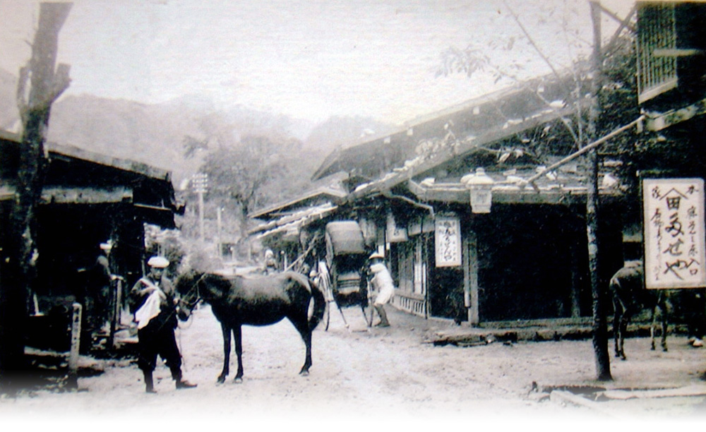
| Kanmachi : Remains of Agematsu-juku Post Town The Kanmachi Area has a few vestiges of the old Agematsu post town, a large part of which was burned down by the large fire of 1950. However, nobody died in this fire, and Agematsu Town was rebuilt over the ruins. |
|
|
| Wakamiya Hachimangu Shrine There are a number of shrines in Agematsu Town. Traditionally, they call the Mt. Komagatake Shrine “Furumiya (Old Shrine)” and the others “Wakamiya (Young Shrine)”. The annual festival of Suwa Shrine with this Wakamiya Hachimangu is held in early September every year, where dedicated Kabuki performances and other Shinto rituals are performed. |
|
|
| Gyokurin’in Temple It is said to have been built in 1579. The black pine tree in the temple grounds has barely survived through a few great fires in Agematsu Town and is said to be 200 years old. |
|
|
| Honmachi Ichirizuka This milestone is marked, “66 ri (260 km) from Kyoto, 72 ri (288 km) from Edo”. |
|
|
| Around Agematsu Station Agematsu Station used to be a log yard. Now, local trains stop at the station. Trains to the north are bound for Matsumoto Sta. and others south to Nakatsugawa Sta. An express service stops once every morning and evening, running between Nagano Sta. and Nagoya Sta. |
|
|
| Ogawa Wakamiya Shrine To the west of the Terasaka Area, across the Kiso River, sits a mountain with this shrine located in its middle heights. They hold an annual festival in late April. The Shishi (lion mask) Kyogen play held in the temple grounds is a sight to behold. |
|
To the Shima District on the opposite bank of the Kiso River |
| Terasaka The name of this area contains the character “tera (temple)” but there are not any temples here right now. However, there is an address named “Kuboji Temple” at the top of a slope, and it was discovered in 1996 that there was actually a temple, built here 400 years ago. It is said to have burned down in a fire. |
|
|
| Miyamae : Remains of a municipal office for logging management Agematsu Town prospered as a forestry town. There used to be a logging management office under the direct control of the clan around the current location of Agematsu Elementary School. |
|
|
| Suwa Shrine The date of the shrine’s establishment is not clear but it is said to have been built earlier than 1599. The annual festival is held in early September. |
|
|
| Nakazawa This is a small river, but a great savior to Agematsu Town. When a large fire occurred 1950, burning down many houses, this creek prevented the fire from spreading further south. It is currently used for agricultural irrigation etc. |
|
|
| Mikari This area is named after the story of an old man from the area who traveled widely but always came back. There used to be a pine tree dating from the Edo Period but it unfortunately died at the beginning of the Meiji Period. |
|
|
| Nezame Tateba -shuku Remain The old buildings remaining at Nezame on the Nakasendo were once the entrance to Nezamenotoko Gorge. The people would pay respect and offer their hospitality to celebrated travelers such as feudal lords. These buildings were used as ryokan/family-run lodge, but they are not in use today. |
|
|
| Japanese Judas Tree The Namegawa River from Mt. Kisokomagatake flowed so rapidly that it often caused disastrous flooding. One day, in the Edo Period, the locals found a Japanese Judas tree that had been carried by the flood waters, it has been a symbol of Nezame ever since. |
|
|
| Omiya Shrine Omiya Shrine was rebuilt in 1636, and its establishment is estimated to go back 600 years ago, by counting the growth rings of nearby tree stumps. The annual festival is held in the middle of July, when a lot of people come to see the dedicated Kabuki and Shishi kagura (Shinto music and dance) performances. |
 |
Up the slope to Omiya Shrine |
| Mt. Kisokomagatake View In Agematsu Town, there are a number of viewpoints overlooking the 2,956-meter peak of Mt. Kisokomagatake in Central Japan Alps. Its granite surface is covered with snow in winter, and the mountain is painted orange when reflecting the light at sunset. It is one of Japan’s “100 famous mountains”. |
|
|
| Namegawa |  |
|
| Ono Falls Located along the Nakasendo Road, Ono Falls feature a vertical drop of 15m and are a great waterfall where travelers would take a break enjoying the scenery in the cool air, thanks to the lack of houses around the upper stream. It has been a famous spot since the Edo Period and is featured in an Ukiyo-e by Hokusai Katsushika. |
|
|
| Kakure Falls | |
|
| Remains of Ogiwara Post Station, Ichirizuka This milestone is marked, “64 ri (256 km) from Kyoto, 73 ri (292 km) from Edo”. |
|
|
| Tono Area Entrance The Tono Area, intersecting with the old Kiso Road, is a place that, in ancient times, people specifically started to settle earlier than other places in Kiso. Located here is Tono Amidado Temple, which was built in this community more than 800 years ago. |
 |
Go under the JR railway track and cross the bridge, proceed 4 km further to reach the Tono Area |
| Tachimachi Post Station Remain The modern national route was developed over many parts of the old Nakasendo, but you can see traces of the original road in this location, left aside from the national route. |
|
|
| Kuramoto Station There is no attendant at this station, from which only a single track extends to the south, as trains only occasionally stop here to let others pass on the main line. |
|
|
| Mt. Utsugidake This 2,864-meter peak is the second highest in the Central Alps. In Kiso, there are two routes to get to the summit, from Kuramoto Sta. and the Ina River. Climbers also pass over here when traversing along the mountain range. |
|
From Kuramoto Sta. to the trailhead for Mt. Utsugidake |
| Kuramoto Ichirizuka This place is marked, “63 ri (252km) from Kyoto, 74 ri (296km) from Edo”. |
|
|
| Agematsu and Okuwa Border Agematsu Town borders on Okuwa Village to the south. Okuwa Village contains Suhara-juku and Nojiri-juku, two of the 11 major post stations in Kiso. In Agematsu, the Nakasendo Road extends north and south for about 12km marked by 4 milestones. |
|
|
| To Suhara-juku |
![]()